Tanzania- Climate & Geography
Tanzania consists of three geographic zones, comprising a narrow coastal littoral along the Indian ocean seaboard, a vast interior plateau and the lakes and mountains of the Great Rift Valley, and the highland ecologies of north, south and central.
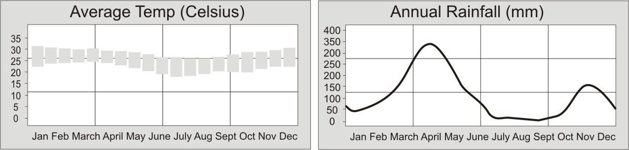
Annual Temperatures and Rainfall as recorded in Zanzibar
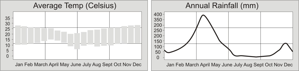
Annual Temperatures and Rainfall as recorded in Arusha
Geography
Coast: The coastal zone ranges from between 10 to 40 miles in depth, and several river extensions, estuarine ecologies and the archipelago feature that includes Zanzibar, Pemba and Mafia Islands. Ecologically the coast is a high rainfall zone and enjoys a lush growth of palms, mangrove and riparian and estuarine forest.
Plateau: The central plateau of Tanzania extends of most of the landmass of the nation and is dissected in two places by branches of the Great Rift Valley. The two branches merge north of Lake Nyasa, with the western branch comprising Lake Tanganyika and the eastern branch extending through central Tanzania, and including the Rubehu and Uluguru Mountains, to Kilimanjaro and Mount Meru in the north.
The plateau also includes the Southern Highlands, or Livingstone mountain range along the northeast shore of Lake Malawi. The Great Lakes structure provides for a massive lakeside ecology that runs from Lake Malawi in the south, up the entire length of Lake Tanganyika and includes the southern half of Lake Victoria Nyanza in the north. The vast central plain is known as the Maasai Steppe, with the Serengeti plain situated above the rift Valley escarpment, bordered by the volcanic region of Ngorongoro Conservation Area and the Kilimanjaro/Mount Meru complex.
Mountains: The principal mountain in Tanzania is Kilimanjaro, a freestanding volcanic cone and the highest point in Africa, accompanied by its sister peak Mount Meru, and several volcanic features associated with the Great Rift Valley escarpment. Smaller mountain complexes include the Pare Mountains in the northeast, the Nguru and Uluguru Mountains in the east, the Livingstone and Kipengere Ranges of the south, the central Rubeho Range and the Mahale Hills in the west.
These are usually high rainfall areas with a higher incidence of ecological diversity and generally areas of high population and intensive agriculture.
Tanzania has no major river systems, but smaller rivers include the Pangani and Rovuma Rivers which flow into the Indian Ocean, the Malagarasi which flows west into lake Tanganyika, and the Kagera which forms the border with Rwanda.
Climate
The climate of Tanzania varies according the geographic zones, but in a nutshell it is universally hot and humid at the coast, with the heat and humid increasing between November and March. Rainfall peaks in April and May, with a second surge between Nov and Dec.
Further inland the climate becomes more temperate, although hot and dry are the adjectives most commonly used to describe it. The peak tourist season is usually between January and February when the warm and dry weather is most attractive and when overland travel is least problematic.
Zanzibar enjoys a warm climate year round that is tempered by the cool sea breezes that have for centuries rendered this a most pleasant and popular place of settlement. Between April and May is the best time to avoid Zanzibar, since this is the peak of the wet season.